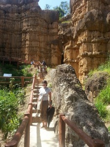
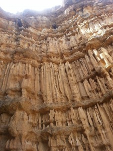
Pha Chor, Chiang Mai. Nature can create many unexpected wonderful things. The passing of time can change the topography of a place and can create strange sights. If you have visited Phae Mueang Phi in Phrae, Phang Ta in Doi Phu Nang National Park, Phayao, or Lalu in Sra Kaew, you can also see the same kind of rock sculptures at Pha Chor and Khew Sua Ten in Mae Wang National Park, Chiang Mai. Pha Chor and Kew Sua Ten are a natural phenomenon of eroded soil pillars. It is believed that this used to be the Ping River watercourse. When the river changed route the site became a hill from the river sediment that piled up into layers. When time passed, it eroded and became cliffs and soil pillars of strange shapes. Similar to Phae Mueang Phi in Phrae and Phang Ta in Phayao, Pha Chor pillars are thirty meters high around a canopy of forest and covers a large area.
To visit Pha Chor, drive to Yang Kram, Doi Lor district which is the location of the Park Security Guard Unit and contact the park officer to be guided through the site. It takes about one hour to travel through the attraction. Khew Sua Ten is another attraction that can be visited in the same trip as Pha Chor. With a similar natural sculpture, Khew Sua Ten is located about one kilometer away from Pha Chor in Yang Kram district and has similar beautiful scenery as Pha Chor with different designs, more pebbles and rocks that can be seen at a lower height.
For a stay over trip in the national park, you can choose to travel to Doi Pha Tang by trekking and staying the night on the mountain on the first day, and then return to Pha Chor and Khew Sua Ten on the second day. Doi Pha Tang is about 1,909 meters above sea level, located in Mae Win, Mae Wang district. Since it is the part of Doi Inthanon mountain range, the weather is cool throughout the year. Due to strong winds along the mountain ridge, there are no tall trees obscuring the view.For those who would not enjoy travelling on the mountain, after visiting Pha Chor, you can relax at the many waterfalls inside the park such as Khun Puay, Pra Duk Daeng, Phong Noy, and Phong Samid
Most of the waterfalls are in Mae Wang district but the most popular is Mae Wang falls because it is close to Pha Chor. It is a single level about twenty meters high and ten meters wide. With the water falling to a basin below and flowing throughout the year, this place is shady and refreshing after a long journey. Excluding the Doi Pha Tang travel program, you can spend almost all day long travelling Pha Chor and Khew Sua Ten, and after that you can drive to Doi Inthanon along Highway 108.
Travel Information
Pha Chor is located in Mae Wang National Park, Doi Lor district, Chiang Mai province. From Chiang Mai city, take highway no.108 (Chiang Mai – Hod) for about 21 kilometers, turn right to Mae Wang district along rural highway no.12039 and no.10240 (Mae Win – Bo Kaew) for about 36 kilometers arriving at Mae Wang National Park with a fine macadam road all the way ,Travel season all year,but is the most beautiful in winter
ผาช่อ
ผาช่อ เชียงใหม่ ธรรมชาตินั้นสร้างสิ่งมหัศจรรย์หลาอย่างที่ยากต่อการคาดเดา กาลเวลาที่เปลี่ยนไปทำให้เกิดการเปลี่ยนแปลงภูมิประเทศที่แปลกตา หากคุณเคยไปเที่ยวแพะเมืองผีที่จังหวัดแพร่มรแล้ว หรือไปเยือนฝั่งต้าในอุทยานแห่งชาติดอยภูนางที่เมืองพะเยา หรือไปเที่ยวละลุในจังหวัดสระแก้วมาก็ดี ประติมากรรมหินเล่านี้ก็มีให้ชมที่เชียงใหม่ด้วย ที่ผาช่อและกิ่วเสือเต้น ในอุทยานแห่งชาติแม่วาง จังหวัดเชียงใหม่ ทั้งผาช่อและกิ่วเสือเต้น เป็นปรากฏการณ์ที่ถูกกัดเซาะโดยธรรมชาติ ทำให้แผ่นดินที่เคยเป็นทางเดินของแม่น้ำในอดีตเปลี่ยนรูปร่างมาเป็นเสาดิน ซ่อนตัวอยู่ในหุบเขาในเขตอุทยานแห่งชาติแม่วาง มาเที่ยวอุทยานฯ นี้แล้ว ยังมีน้ำตกหลายแห่งให้เที่ยวรวมถึงเส้นทางเดินป่าพิชิตยอดสูงที่ดอยผาตั้งอีกด้วย ไม่ว่าจะมาเที่ยวแบบ 2 วัน 1 คืน หรือเดินป่าค้างแรมบนเขาแบบ 3 วัน 2 คืน ก็เหมาะทั้งสิ้น
ผาช่อ เป็นปรากฏการณ์ตามธรรมชาติที่เกิดจากการกัดเซาะของลมฝนจนทำให้แผ่นดินที่เชื่อกันว่าเมื่อหลายร้อยปี หรือพันปีก่อนบริเวณแห่งนี้เคยเป็นทางเดินของแม่น้ำปิง ซึ่งสังเกตได้จากก้อนกรวดหินกลมมนกระจัดกระจายอยู่ในเนื้อดินจำนวนมาก จนกระทั่งแม่น้ำปิงได้เปลี่ยนสายย้ายทิศไหลผ่านไปที่อื่น บริเวณนี้ก็ได้ถูกยกตัวเป็นเนินเขาสูง ตะกอนแม่น้ำปิงก่อตัวทับถมกันเป็นชั้นๆ ผ่านกลายเวลาและถูกกัดเซาะจนกลายเป็นหน้าผาและเสาดินที่มีรูปร่างแปลกตา คล้ายกับที่แพะเมืองผีในจังหวัดแพร่ หรือฝั่งต้าในจังหวัดพะเยา มีลาดลายที่สวยงามและมีขนาดใหญ่มีความสูงราว 30 เมตร สูง เทียบเรือนยอดไม้ ครอบคลุมพื้นที่อาณาบริเวณกว้าง หากคุณจะมาชมผาช่อต้องขับรถมาที่ตำบลยางคราม อำเภอดอยหล่อ ซึ่งเป็นที่ตั้งของหน่วยพิทักษ์อุทยานฯ จากนั้นติดต่อเจ้าหน้าที่อุทยานเป็นไกด์นำทางพาเดินเข้าไปชมผาช่อ ใช้เวลาเดินประมาณ 1 ชั่วโมง ก็เที่ยวได้ครบ กิ่วเสือเต้น เป็นแหล่งท่องเที่ยวที่สามารถมาเที่ยวควบกันได้กับผาช่อ เป็นประติมากรรมธรรมชาติที่คล้ายกับผาช่อ อยู่ห่างจากผาช่อประมาณ 1 กิโลเมตร ตั้งอยู่ในท้องที่ตำบลยางคราม , ตำบลเดียวกัน และมีความสวยงามไม่แพ้กัน ลวดลายแตกต่างออกไปแต่มีก้อนกรวดและหินที่มากกว่า มองเห็นได้ชัดเจนกว่าผาช่อและมีความสูงน้อยกว่าผาช่อ สำหรับคนที่มานอนค้างแรมที่อุทยานฯ วันแรกคุณอาจเลือกเที่ยวที่ดอยผาตั้ง โดยการเดินป่าค้างแรมบนเขา วันที่สองกลับลงจากดอยแล้วค่อยมาเที่ยวผาช่อแฃะกิ่วเสือเต้นก็ได้ ดอยผาตั้งเป็นยอดดอยที่มีความสูงประมาณ 1,909 เมตร จากระดับน้ำทะเลปานกลาง ตั้งอยู่ที่ตำบลแม่วิน อำเภอแม่วาง เป็นส่วนหนึ่งของเทือกเขาดอยอินทนนท์จึงมีอากาศที่หนาวเย็นตลอดปี สามารถมาเดินป่าชมทัศนียภาพได้อย่างสวยงาม ตามแนวสันเขามีลมพัดแรงจึงไม่มีต้นไม้ใหญ่บดบังทิวทัศน์ ชมวิวได้สวยตลอดเส้นทาง ส่วนใครที่ไม่อยากเดินดอยให้เมื่อย มาเที่ยวชมผาช่อเดินกลับเหนื่อยๆ ในอุทยานฯ ก็ยังมีน้ำตกหลายสายให้ลงเล่นน้ำผ่อนคลายด้วย เช่น น้ำตกขุนป๊วย น้ำตกปลาดุกแดง น้ำตกโป่งน้อย น้ำตกโป่งสมิด ฯลฯ น้ำตกส่วนใหญ๋จะอยู๋ในเขตอำเภอแม่วาง แต่ที่นิยมมากคือน้ำตกแม่วางเพราะอยู่ใกล้กับผาช่อ เป็นน้ำตกชั้นเดียวสูงประมาณ 20 เมตร กว้างราว 10 เมตร น้ำไหลลาดลงแอ่งเบื้องล่าง บรรยากาศร่มรื่น มีน้ำไหลตลอดปี เหมาะเป็นที่มาคลายร้อนหลังจากเดินเที่ยวมาเหนื่อยๆ ได้ดีทีเดียว หากตัดโปรแกรมเดินป่าเที่ยวดอยผาตั้งออกไป คุณจะใช้เวลาเที่ยวชมฝาช่อและกิ่วเสือเต้นเกือบวัน จากนั้นช่วงบ่ายจึงขับรถไปเที่ยวที่ดอยอินทนน์ได้ เป็นโปรแกรมเที่ยวต่อเนื่องในเส้นทางหลวงหมายเลข 108 ที่น่าสนใจอีกเส้นทางหนึ่งของเชียงใหม่
การเดินทาง
ผาช่อตั้งอยู่ภายในบริเวณอุทยานแห่งชาติแม่วาง อำเภอดอยหล่อ จังหวัดเชียงใหม่ หากเดินทางจากตัวเมืองเชียงใหม่ ให้ไปตามทางหลวงหมายเลข 108 (เชียงใหม่ – ฮอด) ระยะทาง 21 กิโลเมตร จากนั้นเลี้ยวขวาไปอำเภอแม่วางตามถนน รพช.12039 และถนน รพช. 10240 (แม่วิน – บ่อแก้ว) ระยะทางราว 36 กิโลเมตร จะถึงที่ทำการอุทยานแห่งชาติแม่วาง เป็นถนนลาดยางอย่างดีตลอดเส้นทาง) ท่องเที่ยวได้ตลอดปี สวยที่สุดในฤดูหนาว


Pingback: Beginning of a New Year 2016 part 1 of 2 by jackie | LIFE SE ASIA MAGAZINE
Generally I don’t learn article on blogs, but I would
like to say that this write-up very compelled me to check
out and do it! Your writing style has been amazed
me. Thanks, very nice article.
LikeLike
Thank you for your kind, helpful comments, it will help me improve in the future.
LikeLike
Gorgeous!
LikeLiked by 1 person
Thank you I will forward your comments to her jackie
LikeLike
Thank you for your kind
LikeLike
Wow. Nice pictures, just googled about Chiang Mai to see if I should go back there, looks like I haven’t seen almost anything of it yet. As the French speaking owner of the hotel in the old city suggested I visited Doi Inthanon National Park with a guide, I never thought there were cold places in Thailand with so beautiful forest and waterfalls;
https://www.thainationalparks.com/doi-inthanon-national-park
I also just read about Doi Lang on a blog, seems to have some scenic views there. Thanks for your blog, it helps alot
LikeLiked by 1 person
Thank you for your kind, helpful comments, It will help me improve in the future.
LikeLike